Hydrography
Annual planning
Annual planning
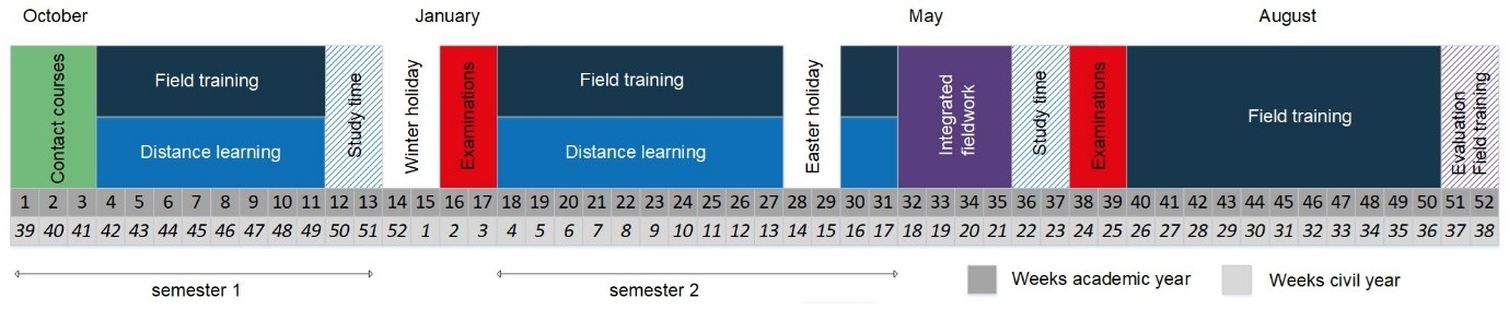
The academic year of the Hydrography Category B postgraduate programme is structured into two semesters, combining on-campus teaching, distance learning, field training, and integrated fieldwork. This blended approach offers students both flexibility and in-depth practical experience.
The year begins with a three-week on-site session at Ghent University, providing an opportunity for students to engage directly with lecturers and peers. This is followed by an eight-week period during which students participate in distance learning or concentrate on their field training. The online courses are accessible through the internet and can be followed at each student’s own pace. A two-week study period, a two-week winter break, and a two-week examination session in January complete the first semester.
The Field Training is an essential practical element of the programme. Students are required to undertake internships in two different companies, totalling a minimum of 90 days. Throughout this process, students document their progress using a Training Record Book, provided by the Institute for Hydrography (IFH), along with personal reports. These tools support the planning and evaluation of the field training experience and help determine whether the learning outcomes have been met. Field training may be completed throughout the academic year and, if necessary, continued during the summer. Students have two opportunities to present their achievements: at the beginning of January and at the end of September.
The second semester begins immediately after the January examination period and spans fourteen weeks. During this time, students continue with distance learning and/or field training. The semester also includes the Easter Holidays, providing a natural break in the academic rhythm.
Following this phase, students participate in a four-week Integrated Fieldwork module. This component includes immersive visits to public and private organisations active in hydrography, as well as hands-on training on board survey vessels and in simulators. A central part of this module is a two-week hydrographic survey campaign in Ostend, covering both hydrographic and adjacent terrestrial aspects of the coastal zone, docks, or inland waters. The collected data is processed and reported by the students. The Integrated Fieldwork offers exposure to diverse real-life scenarios and is assessed based on participation, reporting, and a final presentation.
The academic year concludes with a two-week study period and a two-week examination session. Students who do not pass a subject are offered resit opportunities in September. Additionally, those who still need to complete their internship or finalise reporting for the subject ‘Hydrographic Practice’ can do so during July and August. The final phase of the programme consists of a defence before the examination board, taking place in the last week of the academic year.
Upon successful completion of all components, students are awarded the Hydrographic Surveyor Category B Certificate, officially recognised by the International Board on Standards of Competence (IBSC). This certification affirms the graduate’s proficiency and readiness to operate professionally in the field of hydrography.